
What Might Captain De Anza Notice Today if He Walked the Santa Cruz Riparian Zone?
IN 1775–76, DE ANZA LED A GROUP OF 240 SETTLERS FROM THE SONORAN DESERT TO THE SAN FRANCISCO PENINSULA, PLANTING THE FIRST EUROPEAN SETTLEMENT THERE

When we hear the year 1776, thoughts drift far from Arizona to the East Coast where the Declaration of Independence was being forged. We may tend to focus our attention somewhat narrowly on the activities in the British colonies, and an almost-to-emerge nation of rebels. But while Bostonians were suffering military occupation at the hands of the British, and our founding fathers were contemplating a solution, important things were also happening in the Spanish Empire, specifically in the Sonoran Desert and along the Californian coast.
Tens of Thousands of Years of Human Occupation
Paleo-Indian activity had been going on in the Southwest perhaps 16,000 years in or near the Sonoran Desert. The Tucson Basin was occupied somewhere around 13,000 years ago, a cooler and wetter period, according to researchers Thiel and Diehl of Desert Archaeology, Inc. Early groups were active here performing agriculture along and near the Santa Cruz River corridor that runs along the base of the Tucson Mountains on the west side of the basin that Tucson, Oro Valley and Marana fill out today. Footprints made 2,500-3,000 years ago during the agricultural activities of several adults, and at least one child, were found as recently as 2015 near Tucson close to Interstate 10 during excavation for a building. They are currently the oldest footprints in the Southwest. (1) The creek near that crop-tending activity overran its banks shortly after the prints were made, preserving the record in mica-rich, sandy sediment, according to archaeologists. Irrigation features and places where crops were planted were also preserved as a snapshot in time.

Across the Sonoran to Supply Alta California
In 1774, New Spain had control along what is today the coast of California, known then as Alta, or high, California. The New Spanish state of Baja, or low, California still exists as the upper part of a peninsula on the west of the Gulf of California sitting directly below modern California (then Alta California). The peninsula is completed by Baja California Sur, or south, at the bottom tip.
The Spanish Empire claimed control of vast areas of both South America and North America much larger in total than the area covered by the British Empire. Russia was actively trading and entrenched as far down from Alaska as just north of present-day San Francisco.
That same year, following ideas promoted by his father and years of convincing officials to support him, Juan Bautista de Anza, a Captain in the army, and 29 others blazed a land trail through the Sonoran Desert from the presidio at Tubac, and arriving at Monterey in Alta California. The sea route along the coast of South America to the California coast was long and dangerous. New Spain had been having difficulties supplying its Alta California outposts, and a collapse was possible. De Anza, and earlier his father, had promoted the land route as a more reliable and direct method of supplying the frontier.
On October 23, 1775, Captain De Anza started from Tubac again with a larger party to colonize and fortify the land route with villages and missions and begin the new system of support along the coast of Alta California. The group of 245 traveled down the Santa Cruz River, which is to say they went north. The Santa Cruz, an international river that catches a small part of Sonora in Mexico, flows north and empties into the Gila River which very quickly picks up the Salt River heading west with the cumulative flows of a large basin of tributaries. The Gila then flows mostly west from there until it joins the Colorado working south toward the Gulf of California, also known as the Sea of Cortez. With even a third, seldom-used name, the Vermilion Sea is believed to be one of the most diverse on Earth.
The colonizing expedition camped at several places along the Santa Cruz in Pima County, camp stops 15 through 20 as they are referred to. Tucson was a “visita” of the mission at San Xavier del Bac, but not a permanently occupied location, as referred to in the diary of Frey Pedro Font of the expedition. That stop was camp number 18. (2) In 1776, the garrison from Tubac presidio was moved to the location near that location and named San Augustin de Tuquison, which was the occupied start of European Tucson. The corridor covered by the expedition from Tubac to its exit from Pima County is very close to the route followed today by Interstate 10.
Eventually, the party reached and established a mission and presidio at what is today San Francisco countering further Russian incursion from the north. Both outposts were literally thousands of miles from their respective capitals. San Francisco is 5,790 miles from Madrid as the crow flies, and St. Petersburg is 8,862 miles from San Francisco point-to-point. The fact most supplies from Russia were sent by land route which was much, much farther, and from Madrid by sea, which was also much, much farther, brings to mind the modern-day challenges of planning to supply bases on Mars. So both locations were isolated, fragile, hanging by threads and surrounded by various indigenous groups far better equipped.
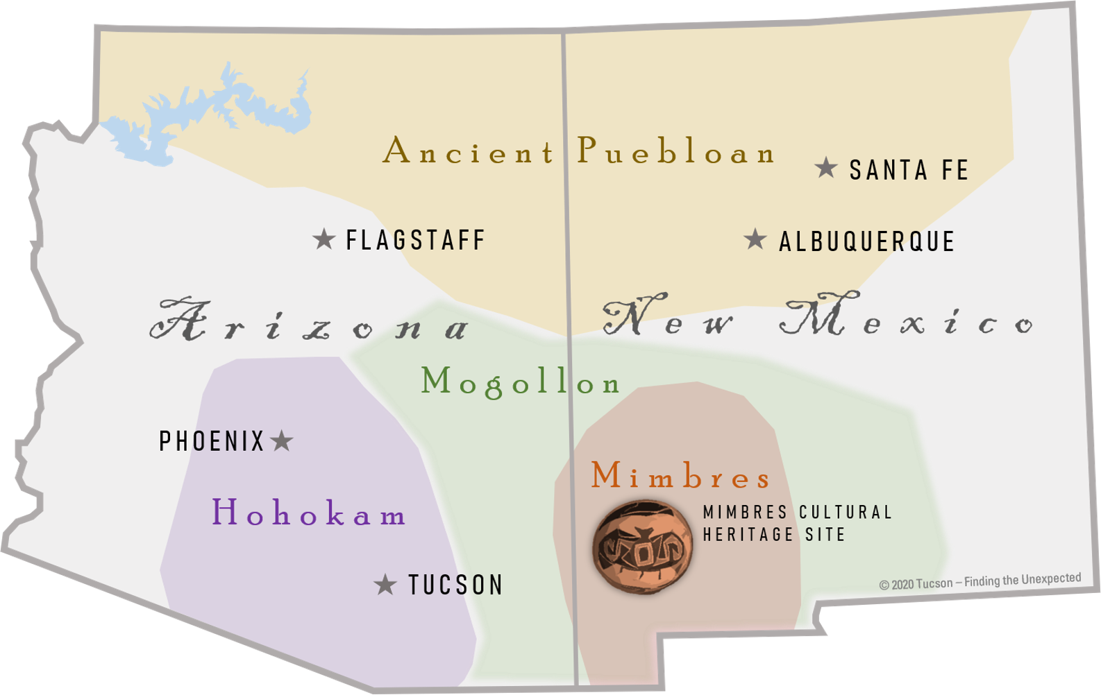
Paleo Indian regions (pre-historic groups preceding modern-day indigenous tribes) of Arizona and New Mexico.
What Did They Think of the Sonoran Desert?
The Sonoran Desert extends much of the way into what was then the New Spain territory of Sonora, from which it gets its name. So many in both expeditions – exploratory and colonizing - came from or through extended expanses of this desert in their travels. The route to the California coast remains in the Sonoran Desert’s western extents to within under 100 miles of modern-day San Diego.
The diaries kept by De Anza, Frey Font and Francisco Garcés were scant on impressions of the desert surroundings through which the party traveled. Overall, the colonizing expedition was successful, one woman lost her life between Tubac and camp 17 at Mission San Xavier del Bac following childbirth. Three children were born along the route. Indian encounters were either uneventful or very positive to the success of the group. Because the expedition was military in nature, it probably made the official written narratives more businesslike than descriptive. So clues are not abundant as to what they were thinking about the country through which they were riding. De Anza recorded that the Army provided 220 mounts and the colonists another 120. There were 140 pack mules at the beginning of their campaign.
But we do know careful observations were being made. Moving the garrison from Tubac to the present-day location of Tucson had to be done based on an analysis of the location and surroundings. Further north, the expedition lengthened their trip to investigate what today is the Casa Grande Ruins National Monument. Casa Grande is a Hohokam (Pima Indian term for “all used up” or “exhausted”) Paleo Indian site, but the Spaniards incorrectly connected it to Montezuma.
On an earlier expedition, Father Kino had described the ruins, and De Anza’s party further surveyed the building remains and checked on Father Kino’s original descriptions. Eusebio Kino was both a missionary and explorer who came long before De Anza. He traveled the entire Southern Arizona area, starting many of the missions including San Xavier del Bac just south of current-day Tucson. In 1691, Father Kino undertook the first of his approximately 40 expeditions. In 1694, he was the first European to visit the Hohokam ruins of Casa Grande which he wrote about, as he did all of his explorations. His contact with the ruins would have been only about 250 years after they were in active use, ending in about 1450. Although the De Anza investigators did not surmise the ruins were of local origin, they did study them in some detail to compare with Kino’s records and add where possible.

"We had an opportunity to go and examine the house that is called La Casa Grande de Moctezuma ... We were accompanied there by several Indians ... who told us on the way a tale and tradition regarding the house, handed down from their forefathers."
- Diary of Pedro Font, Oct. 30, 1775 (3)
Other evidence of study might be inferred from the fact that trail-supporting villages were begun at key locations, such as Yuma where the Gila deposits its waters into the Colorado. The lives of those left behind as colonists were dependent upon the expedition’s observations and decision-making. While there are not many commentaries of the extent and style an explorer like John Wesley Powell and his party left almost one hundred years later as they explored the Grand Canyon of the Colorado, the expedition must have waxed poetic at least in their thoughts about the beauty and the expansiveness they observed. Of the three chroniclers whose records remain, Font added the most color.
What Differences Might De Anza Notice?
If Captain De Anza were to travel along the Santa Cruz River through Pima County today, 246 years following his return from San Francisco, what might be some of the changes he would ponder? First, he might take solace in the fact that Camp 17 at San Xavier del Bac would probably look familiar. However, the mission itself would not. Until construction of the current structure began in 1783, there was a period of about 13 years where the original church built near the site in 1700 was destroyed in an Apache raid. While the mission itself continued, both expeditions moved through at a time when there was no formal church.
Obviously, where there one was a flat expanse of desert floor to the east of the Santa Cruz running to the Santa Catalina Mountains, there is now a major metropolitan area.
The Santa Cruz River itself is also different. In historic times its route, which begins in the United States to the east of Patagonia in the Canelo Hills and flows past Santa Cruz, Sonora, Mexico, before returning to the United States, was not filled year-round in all sections. However, it did flow on the surface in more places in De Anza’s time than it does today. That allowed the expedition a route that offered water for part of the Arizona journey.
We can gather some description from times not too long after De Anza passed. 79 years later, a traveler headed to California who would edit the German newspaper, Daily San Francisco Journal, described the Santa Cruz valley in these terms:

"... the banks of the river, and the valley itself, are covered with poplars and willows, ash-trees and plantains, oaks and walnut trees ... Some portions of the valley are of such grand, rich and simple beauty, as for instance Tumacacori and San Xavier del Bac, that they would be remarkable in any part of the world."
– Traveler Julius Froebel, 1855
Today, De Anza would have more difficulty finding flowing sections. As the town of Tucson has grown, and as ranches and farming in the Sonoran Desert have increased over the past two and a half centuries, two principal interruptions to flow have occurred. First, more water has come out of the river itself to be used for plants, animals and people. Second, the water table has dropped, due to pumping out water from the large aquifer underlying much of the Tucson basin, contributing to more sections that still run, but now run underground.
Until the 1940’s, fish could still be found in the Santa Cruz that are not seen today. They may have, and probably did provide some modest meals for the expedition members. Species included the Gila top minnow, pupfish, Sonora sucker, desert sucker, long-fin dace and Gila chub. (4)

Mesquite Bosque along Santa Cruz Riparian Zone, 1800s.
The floodplain is also different. Summer monsoons would gently flood the surrounding areas of some sections with water and silt, providing areas where civilizations such as the Hohokam adopted agriculture successfully. The Santa Cruz now flows through more of an “incised” channel in the Tucson area. In De Anza’s time – and for perhaps thousands of years before - there was a bubbling spring at San Xavier del Bac, and marshy cienegas with mesquite bosques and cottonwoods lined the riparian boundaries. As the river has been channeled through the metropolitan area, it has changed in character from a green ribbon of interlocking oases to one members of the expedition might see as less pleasant. Monsoons today are believed to be more sporadic and harsher on average as well. What may have been a frequent brief rain in the late afternoon is today more often a more dramatic storm with more dry days between. These changes in monsoon character may be due to climate change in general and a long-term drought that began about the time the latest century was rung in. It is the same type of drought cycle that in the 1400s cleared much of the Southwest of some of its greatest Paleo-Indian groups, at least in concentrated population centers. Those groups are still with us, and we know them by different names, and they often live in different areas.
There are current efforts underway to improve the flow and character of the Santa Cruz River, however it is unlikely this area will ever again be the connected chain of oases it was for the De Anza Expedition.
Other Changes

Captain De Anza, founder of San Francisco. Photo by Michael Fraley San Francisco. License
The appearance, flora and fauna of the corridor has changed in other ways. De Anza and Fray Font might be interested to see long sections of pavement, a few parks and bridges forming trails where they traversed the desert. They might be amused to read interpretive panels along the paths they made and followed.
Native to Africa, the Middle East and Indonesia, buffelgrass has spread in many segments of the Sonoran Desert. It was brought to the Southwest and used as forage for animals. This invasive species crowds many indigenous species and competes for water with larger plants, weakening diversity and, in turn, dependent animal and bird life. Buffelgrass also creates ready fuel for fires, for which the Sonoran Desert is not ecologically adapted. When a buffelgrass fire takes place, it often destroys most of the remaining native species of plants.
A few years after the expedition passed, in 1789, Torbio Ortero established a ranch in the valley just north of Tubac. Father Eusebio Kino drove cattle into the area as early as 1696. From the establishment of Ortero’s ranch, many others through the 1800’s brought and raised livestock in the area.
Saguaros, the iconic and unique Sonoran Desert dweller, have been heavily impacted by ranching. Livestock trample young plants that are not under the protection of an established tree or bush, known as a “nursing plant.” In some areas De Anza and his party would have seen Saguaros covering, these later were thinned as a result of ranching.
Cienegas are marshy areas unique to the American Southwest and have been disappearing in the 200 years since human development increased dramatically in the Sonoran Desert. These areas are literal oases that provide homes for an amazing range of animals, reptiles and plants. What started with the increase in population marked by events like the De Anza colonization expedition has contributed to the rapid decrease of these areas.
One of the contributing factors to loss or degradation of the cienegas is the lowering of the water table. Much of the water used for farming, ranching and cities is in part or in whole provided from aquifers residing under the region. The recharge rate of these storage vessels has been much slower than the rate of removal as an increasing number of wells have been drilled and more use has occurred. As water tables fall, cienegas have dried up.
Livestock brought in beginning in the 1700s, particularly sheep, utilized the once numerous cienegas heavily, trampling the habitat and destroying it in the process. (5) Now on the edge of disappearance, cienegas are no longer numerous. The Bureau of Land Management controls an area near the transition lands between the Sonoran Desert and the Chihuahuan Desert called Las Cienegas National Conservation Area to the southwest of Tucson. More information can be found at www.blm.gov/visit/las-cienegas.
Corridor to Transition
The corridor followed by Captain De Anza and his colonists has changed a great deal since their time. The rate of change is rapid and is worth consideration as more human intervention changes the face of this fragile and completely unique desert environment more as time passes. However, its beauty and uniqueness are still undeniable.
1 January 21, 2016, Blake de Pastino, westerndigs.ORG
2 nps.gov
3 National Park Service, Juan Bautista de Anza National Trail, NPS.GOV
4 Margaret Regan, “A River Ran Through It,” tucsonweekly.com
5 Wikipedia, “Cienega”
