
THE FAILED PROMISE OF A RAILROAD HUB
New Mexico Chapter 3
INTRO EUROPE GERMANY OHIO INDIANA SOUTH DAKOTA NEW MEXICO KANSAS DEEPER LOOKS BOOK

The train that never pulled into Obar
“RAILROADS.
“Obar is most fortunate in its location, as is the case with all other towns destined to become cities, by its being located on the main line of the Rock Island System, 53 miles from Dalhart, Texas and 40 miles from Tucumcari, New Mexico. It is also on the proposed line of the Mineral Wells & Northwestern, which will run from Trinidad, Colorado, to Ft. Worth, Texas. We feel reasonably certain that on account of the distance from Trinidad, Colorado, being about 100 miles, Obar will be the first division point on this new line.”
- New Mexico Land & Immigration Company
Whether there were realistic reasons to believe the Mineral Wells line would be extended through Raton Pass and on to link to the Santa Fe Railway and Trinidad, CO, is unknown. At the time of promoting Obar, the Mineral Wells line was local and very limited in the Texas region just east of Fort Worth.

The Rock Island line arriving in Obar, NM, from the southwest with the station on the north side of the tracks. The prior town of Perry, NM, and its station were originally south of the tracks, but moved after only a couple of years.
Both the New Mexico Land and Immigration Company of Topeka, and the Weatherford, Mineral Wells and Northwestern Railway, controlled out of Kansas City, were Kansas operations. Their offices were in proximity to have had business dealings and connections.
The Atchison, Topeka and Santa Fe, also of Kansas, was headquartered in Topeka, so perhaps there were sufficient plans or discussion of plans at the time to suggest the route was intended to cross the Rock Island at Obar.
Or, perhaps it was all a ruse, from which there would be little protection in that day.
From the Texas State Historical Association:
“The Weatherford, Mineral Wells and Northwestern completed twenty-five miles from Weatherford to Mineral Wells in 1891. That year the company owned two locomotives and ninety cars. In 1895 it earned $15,561 in passenger revenue and $38,070 in freight revenue. The line was bought by the Texas and Pacific Railway Company in 1902 and extended eighteen miles from Mineral Wells to Graford in 1908.”
- Cris Cravens

The Mineral Wells and Northwestern line was a localized line with modest resources. It does not appear to be a line that would have designs on suddenly building 400 miles to the northwest to reach Obar, NM, and then further into Colorado.

Why did someone think the Mineral Wells line would reach Obar?
While Graford was indeed northwest of Mineral Wells, thus fulfilling the “Northwestern” part of the original name, it was not very far northwest. Obar, NM, was another 400 miles away. An article in Railway Age dated 1907 said the line had just been extended to Oran, TX, which was almost directly north of Mineral Wells. The article said the extension “to Pickwick” (submerged under a reservoir today) had completed another “30 miles to Oran.” That route might have appeared as in the suggested map above.
If the goal was bringing traffic, both freight and passenger, from Fort Worth, through Weatherford, Mineral Wells and on to Trinidad, a much more direct route would have taken the line through Amarillo. In 1910, Amarillo had a population almost 10,000.
It may never be determined if there was ever any reasonable chance the Weatherford, Mineral Wells and Northwestern Railway would be extended as suggested by the New Mexico Land and Immigration Company. It was something Edna Link recalled over 60 years later as a promise that was made, but not kept. An omission with many long-term consequences for the citizens of Obar.
No rain, no train, no gain
The concept of Obar as pitched by the New Mexico Land and Immigration Company was hampered by two main factors.
Those two factors proved fatal to proposed farmland surrounding a city built from scratch on the arid plains of eastern New Mexico. Regardless of how skilled, dedicated and hard-working the sturdy Americans who immigrated there were.
First, there was not enough rain to farm all but some unusual vegetation for which there was no on-going market found. The climate was better suited to ranching, which goes on there today. New Mexico ranchers might expect to feed a cow on 45 acres. In states like Indiana where the Links lived for over a generation, a rancher might expect one cow to require 2 to 2.5 acres, depending on many factors. But ranching in that region had been and remained possible.
Second, there was no future railway being built toward Ober to increase the business and economic value of the city’s location. From its history, the Mineral Wells line appears very much the same as a large number of other “short lines” that filled gaps, then were absorbed by major railroads or abandoned. Whether there was good reason to believe in such an expansion is, so far, not rediscovered.
The result of these combined factors numbered the days of the homesteaders of Obar and the townspeople as well. Cities such as Nara Visa “up the road” (to the east) and Logan further southwest were in similar circumstances.
Tucumcari Tonite!
A neighbor of Obar, Tucumcari, NM, actually did become a railroad hub, then a travel hub through the 1960’s. 41 miles away from Obar, to the southwest on Highway 54, Tucumcari today honors its traditional spot on Route 66 as a place to stop for the night. In 1950, Tucumcari peaked in population at nearly 8,500. Today there are about 4,800 living within the city. The El Paso and Northeastern Railway crossed the Chicago, Rock Island, and Pacific Railroad (which went through Obar) at Tucumcari.
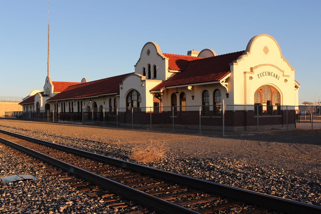
Tucumcari’s railroad depot, re-opened as a museum after renovation completion in 2015. Photo: Joseph, Flickr. License.
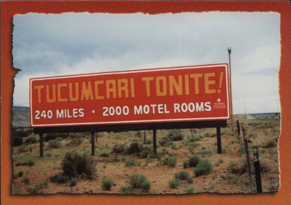
Advertised for hundreds of miles in different directions, Tucumcari, NM, was the spot for generations of automobile travelers to make it to “tonite.”
